PASS-SWIO

Portagauge and Satellite Sea Level Monitoring System for the Southwest Indian Ocean


Home | Documents | Data | Publications | Training

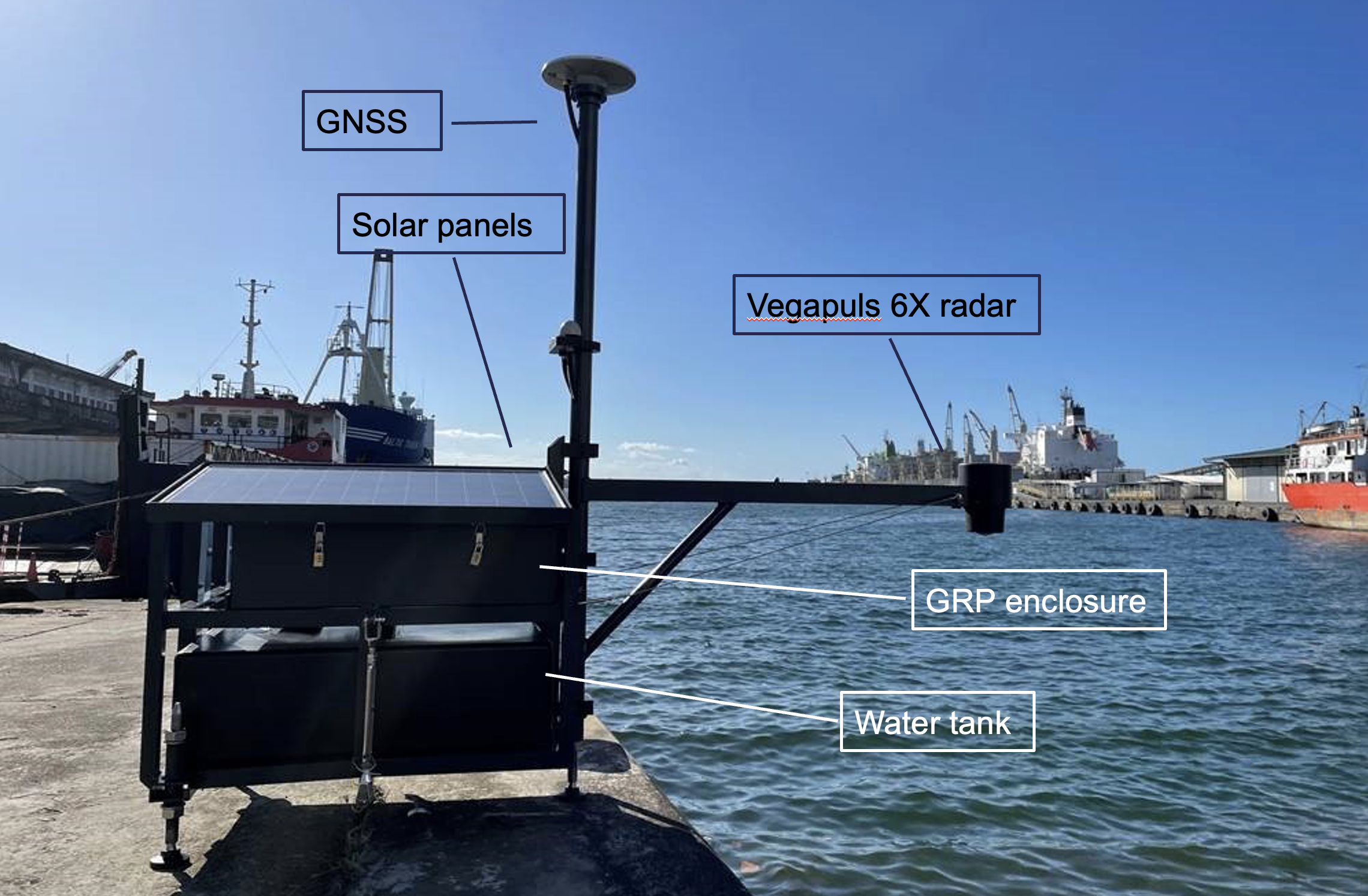
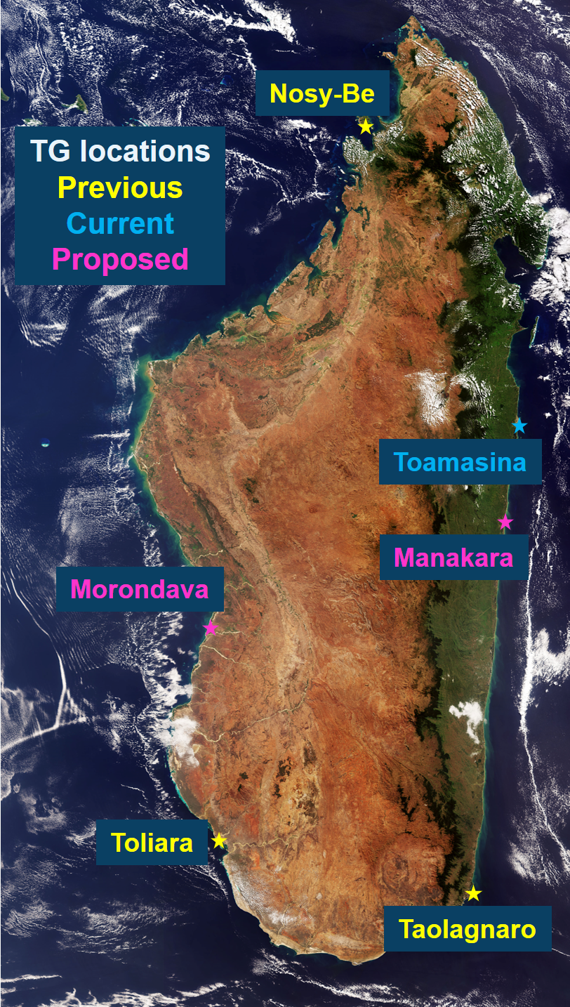
PASS-SWIO is a project funded by ESA which aims to establish a sea level monitoring system for Madagascar based on the installation and deployment of a low-cost relocatable tide gauge (Portagauge). Portagauge uses GNSS interferometric reflectometry (GNSS-IR) technology alongside a conventional radar. By combining these measurements with the analysis of satellite altimeter sea level data we will provide validation and wider scale knowledge of sea-level variability.

Madagascar has very limited tidal prediction, primarily based on model data. It has no national sea level monitoring capability. There is currently only one functioning tide gauge station. A previous tide gauge, in the cyclone-prone north of the island, was destroyed several years ago.

The project partners will work with the national Madagascar Meteorological Agency (DGM Direction Generale de la Meteorologie). DGM will take responsibility for the local maintenance and operation of the Portagauge. They will also receive training to carry out the data processing and analysis of tide gauge and satellite altimeter data.

Discussions will be held with key stakeholders to review the project and agree a long-term Road Map for the sustainable implementation of a national sea-level monitoring system for Madagascar. This will serve as model for other island states and coastal countries in the South West Indian Ocean (SWIO) region and beyond.

If you would like to access any of the data sets produced, please contact the Project Manager (see below).

Latest news

Near Real Time Data for the Madagascar Region

A Data Demonstration page, set up for the C-RISe project, is available, which shows near real time satellite wind, wave and surface current data together with present model forecast conditions.

Sea Level Requirements Questionnaire

To help the project develop a plan for a sustainable sea- level monitoring system for Madagascar, we need to understand requirements in Madagascar for sea level information, and gaps in current availability. This information is very important to provide justification for any recommendations that we make, and to support proposals for future funding.

We are inviting anyone with an interest in sea level measurements for Madagascar to complete a short online questionnaire. This questionnaire is available in French or English, through the links below:

French Language Questionnaire
English Language Questionnaire

Webinar for Users 14 September 2022

An important aspect of PASS-SWIO is to engage with current and potential users of sea level data in Madagascar to understand the main requirements for sea level information, and gaps in current availability.

To support this objective, a webinar was held on 14th September. The webinar introduced the PASS-SWIO project, provided scientific context to sea level change in the South-West Indian Ocean, and introduced an online questionnaire.

5 presentations were made and are available through the links below:

A recording of the workshop is available on youtube at https://youtu.be/CfJy5EfaHf4 


Study area

Madagascar, showing previous, current, and proposed Tide Gauge Locations, and Toamasina Harbour


Contact

Project Manager: Amani Becker, NOC (abeck at noc.ac.uk)

Project activities

Work Package 1000 User Engagement & Capacity Building:

  • Training to local DGM staff on Portagauge installation and data processing
  • Engagement with stakeholder agencies in Madagascar
  • Project website with links to data

Work Package 2000 Portagauge Manufacture, Installation & Operation:

  • NOC will finalise the design and manufacture of the Portagauge
  • NOC and SatOC will organise the shipping of the Portagauge to Madagascar and it will be installed at the first site with assistance from DGM
  • Operational monitoring of the instrument and data will be carried out remotely by NOC and in situ by DGM

Work Package 3000 Sea Level Data Processing:

  • Processing and analysis of sea-level data from Portagauge to output quality controlled time series
  • Processing of satellite altimeter data from Jason and Sentinel-3 to output quality controlled along-track Total Water Level Envelope time series
  • Cross-validation of satellite and Portagauge data
  • Analysis of tidal and non-tidal sea level variability characteristics

Work Package 4000 Sustainable Implementation Road Map:

  • Identify and document the requirements for Malagasy sea level monitoring capability through consultation with stakeholders
  • Draft plan of future Portagauge deployment sites in Madagascar
  • Generate road map, with input from stakeholders, for sustainable implementation of sea level monitoring

Key Dates and Meetings

Project Kick Off (May 2022): Planning and confirmation of project timetable

Stakeholder Meeting (June 2022):  (Online meeting) Introduce project, establish requirements for improved sea level monitoring

Portagauge Installation (October 2022):  Installation of Portagauge in Madagascar and training for operation

Mid Term Review (October 2022):  Review of progress, confirm planning for second phase

Training (March 2023): (in Madagascar) Processing, assessment and validation of data from installed portagauge

Stakeholder Meeting (March 2023): (In person) Presentation of project results, discuss recommendations

Final Review (April 2023): Presentation and review of project results

Project team

noc    satoc  


© Satellite Oceanographic Consultants Ltd 2022