|
About | Search | Projects | Services | Data | Publications | Contact |
 |
|
Data: Calibration and Validation |
||
|
|
||
|
SOS is involved in the callibration and validation of altimeter wave measurements from the following satellites: Geosat Follow-OnFollowing problems after launch, GFO is now working properly. See note on the early calibration of IGDR's here, and calibration of GDR's here. TOPEXLaunched in 1992, the TOPEX/Poseidon mission is still providing quality altimeter measurements giving the longest service of any ocean monitoring satellite. Transmitter A malfunctioned, and was replaced by B in January 1999. See notes: WAVSAT
calibrations (A & B) here, ERS-2ERS-2 has been operating since 1995. (But some onboard recording devices have failed and global coverage of altimeter data is no longer obtained.) Download the latest altimeter calibrations here (256k Word document). JASONJASON(successor to TOPEX) was launched on 7th December 2001. Contact d.cotton @ satoc for the latest calibrations of wave height and wind speed. ENVISATLaunched in March 2002. Initially there were problems with some sensors, but now they all appears to be operating well. Calibrations against buoys and other satellite altimeter data are progressing. |
6m wave buoy, typical of those used to calibrate altimeters.
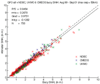
Calibration graph showing altimeter wave measurements against buoy values in a variety of locations.
|

|
|
||