|
About | Search | Projects | Services | Data | Publications | Contact |
 |
|
Products and services |
||
|
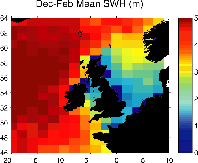
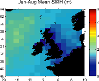
SOS provides products and services in global wave and wind statistics and near real-time metocean data. Clients include the offshore industry, shipping, government institutes, private companies and research institutes. Global wave statistics: WAVSATSOS maintains a continuous record of satellite observations of wave height and surface wind speed which began in 1985 with the launch by the US Navy of the first operational spacecraft to carry a precise radar altimeter. The Wave Group was given a big boost when SOS won 2 out of 6 awards in the first of the BNSC's Application Development Programmes. This enabled them to develop and populate two data archives referred to as WAVSAT and GRAVSAT from the recordings of the radar altimeters. On completion, GRAVSAT (for the calculation of gravity anomalies over the sea) was passed to the British Geological Survey. WAVSAT continues to be added to every day. Such an archive is unique in providing uniform coverage of the global oceans. SOS has developed the technology required to check the quality of the data and store them by geographical location in a format that allows rapid extraction of the information required to derive reliable wave climate statistics. Monthly average and extreme values are calculated along any given route or for any single location. These quantities are becoming increasingly relevant to a wide variety of marine operations and the SOS customer base for this information continues to expand. Near real-time data services: SSAThe Sea State Alarm (SSA) service was first developed in the mid 90s when SOS became the first organisation in the world to allow easy access to the global wave and wind fields measured over the previous 24 hours by the ERS-2 radar altimeter. The service has now evolved into a database of all wind and wave data available in near real-time, and fast delivery data services are provided to shipping and forecasting services worldwide. |
The mean significant wave height around Britain for winter (top) and summer, calculated from the SOS archive.
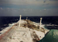
An oil tanker having a hard time in rough seas. Heavy seas such as this cause delays and increased fuel consumption.
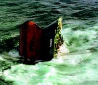
The sinking of the 'ERIKA' in severe weather caused major oil pollution. This might have been prevented by Sea State Alarm. |
|
|
||