|
About | Search | Projects | Services | Data | Publications | Contact |
 |
|
Projects and project management |
||
|
GAMBLE | Clean Seas | Comkiss | Jericho | Success | Ocean Currents | EOSSOP | CAMMEO |
||
|
SOS has acquired a wide experience in the management of multi-discipline, mostly multi-national, applied research investigations of the marine environment. For several years SOS has been closely involved in studies sponsored by the European Commission in Brussels, the EC's Joint Research Centre at Ispra, the European Space Agency, ESRIN (Frascati), NATO Undersea Research Centre, and the British National Space Centre's LINK Programme in tandem with the Environment Agency. Clean Seas (EC, DG XII)A programme involving 8 of the top research laboratories in Europe drawn from 6 countries which over a period of 3 years provided a dramatic demonstration of the extent of marine pollution over 3 inland seas - the Baltic, North Sea, and Gulf of Lyons. Drawing mostly on a detailed analysis of many hundreds of radar images of the sites acquired by the ERS-2 SAR, and supplemented by colour imagery from SeaWiFS, the Clean Seas team provided convincing evidence that the international conventions aimed at protecting the seas from unwarranted dumping of waste oil at sea are being frequntly flouted. COMKISS (CEO, Ispra)Another multi-national study aimed this time at representative members of the shipping industry who joined as active participants and helped formulate its conclusions. These organisations were the Bureau Veritas (the French register of ship certification); Dockwise, the largest company in the world for the transport at sea of unconventional loads; and the high speed ferry company, Corsica Ferries. Increasingly, SOS is working with clients active within the marine community to demonstrate to them how the products of marine remote sensing could provide cost benefits to their operation. ISOLE (EC, DG XII)The acronym spells the Italian for 'islands' and this study was aimed mainly at the two Mediterranean islands of Mykonos and Elba, for which summer tourism is by far the main industry; SOS assumed responsibility for the acquisition and analysis of the radar imagery commissioned over the 2 sites. The main thrust of the investigation was to take the first steps in providing an easy-access Coastal Information System to monitor the threat of pollution both to the island from passing ship traffic and from within through the greatly enhanced summer population. DESIMA (CEO, Ispra)Matra France was the lead organisation in this investigation to establish a versatile decision-making tool for coastal managers. Again, the emphasis was on the development of a coastal information system which would merge information (in situ + remote sensing) with models to predict the fate of a pollution incident. The SOS role was to deliver the information derived from remote sensing observations over two areas �one in the Channel, the other the Gulf of Lyons. The features demonstrated were temperature, wind/wave statistics and the prevalence of pollution in the area revealed by Clean Seas. JERICHO (BNSC/EA)This was a LINK programme carried out with the NERC institutes, Southampton Oceanography Centre and Proudman Oceanographic Laboratory (Bidston) together with Sir William Halcrow Ltd. The aim was to determine if the increase in winter wave height observed by SOS in the North Atlantic over the last 15 years might be felt along the shores of the English and Welsh coasts, and how such a trend was translated into programmes of coastal defence which is the responsibility of the Environment Agency. MED CONNECTIONS (ESA)A study carried out jointly with JRC, Ispra to study the correlations between seasonal trends in wave height and surface wind speed over the Mediterranean (derived from the SOS multi-year archive), and surface temperature and colour derived from the archives of AVHRR and CZCS held at JRC. Rapid Environmental Assessment (DERA)SOS personnel have worked closely in the past with DERA on a number of studies mostly associated with ESA development programmes including a study of the options for re-visit times of the satellite repeat tracks. More recently SOS completed a report commissioned by DERA on the use of EO satellites in Rapid Environmental Assessment of the Coastal Zone. |
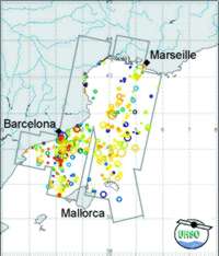
Many different oil slicks were identified from SAR images in the northwest Mediterranean (above), the North Sea and the Baltic Sea during the Clean Seas project.
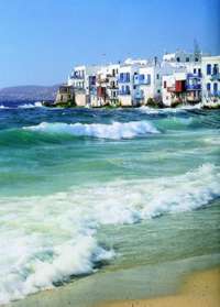
The Island of Mykonos, together with Elba, was a study area for the Isole poject.
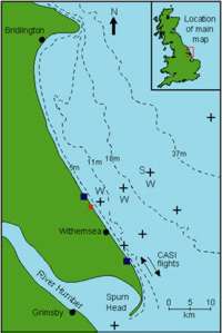
The North Sea study area for Jericho at Holderness. Jericho studied the way offshore waves translate to the coast at three areas around Britain, on the East coast, the South coast and the coast of South Wales. |
|
|
||